Skookum Volcano

Mt. Skookum is a young but destroyed volcano in Wrangle St. Elias National Park. The park is larger than the country of Switzerland, so the NPS doesn't have much money for trail maintenance or building. There are not many trails to choose from, so i chose the only one that looked like i could both get to it and do it in a day, the Skookum Volcano trail. But after reading it i wanted something more, like a loop trail, so i chose to try the Skookum to Rambler Mine loop trail.

I found this perfect hidden campsite in the woods along Skookum Creek (pictured at top). I slept listening to the creek and in the morning went over to Devil's Mountain Lodge where i had a great breakfast. Then i came back, broke down camp, made lunch, and headed for the volcano.

This is what Skookum Volcano looks like from the northwest.

...and this is what it looks like from the northeast.
I picked this trail at home before i had even been in the north half of the park. It said you would almost certainly get your feet wet due to crossing a stream several times. I'd rather be waterboarded than get my feet wet and i knew the trail was rugged so i went and got some hiking poles. This was the first trail where i have ever used hiking poles but it was the perfect outing for them and they definitely kept my boots dry.

After a mile you have to start crossing this creek over and over. Sometimes it's easy, sometimes it's not.

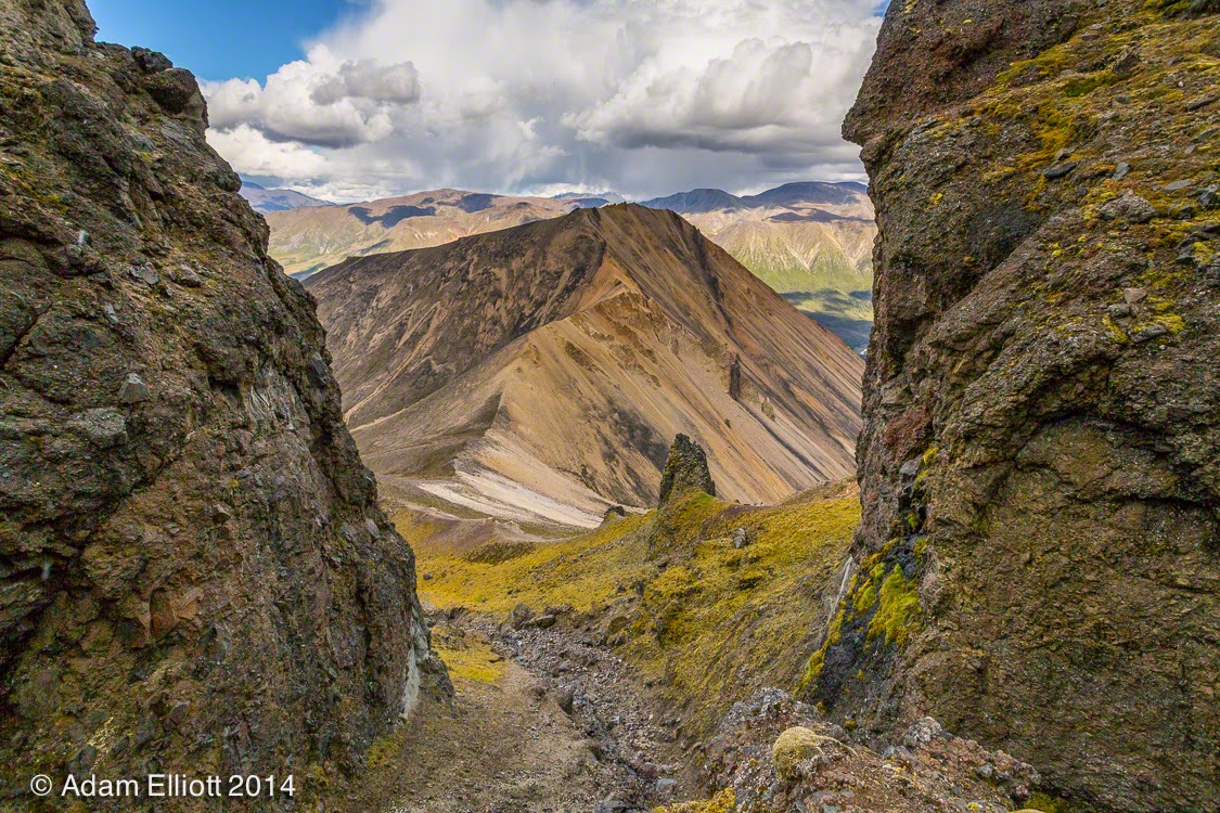
Up ahead there was a cool rock formation that looked like a double tunnel with the top removed. I hoped the trail would take me over there but it did not. I should have gone to check it out. I think i could have ended up at the pass in the same amount of time.

One of many erosion resistant dikes embedded in the area.

The headwall i was climbing towards looked like backbone of Oahu.

There wasn't a cloud in the sky when i started hiking but two hours later i was surrounded by showers.

A panorama from the top of the pass looking into the next valley

It was very rugged looking and weird up there, but what is that crazy thing the upper right?

It looks like some crazy tower from the Lord of the Rings! If i could just get to it, i might be able to bring Sauron back from the dead, and rule the world. Looked hard to get to but according to my map i might be passing close to it...
The stream forks a couple of times, narrowing with each division. The rugged nature of the traveling forces you to go slow, picking every step. That was a good thing, as it kept me from getting very out of breath. After another mile you reach some steep tundra and make your way onto a high ridge pass. That is the end of the official "trail".
From there i began the "route" by walking straight up the ridge to some volcanic cliffs. Getting through the cliffs involves doing some real climbing up through a narrow notch full of very loose stones and brittle handholds. My timing could not have been worse. Although i started without a cloud in the sky in just a few hours storms had built up on all sides of me. Several of them passed by but my luck finally ran out and a storm came over the top of the mountain. While i was climbing the cliff it started raining and in a few more minutes i was in a cold mountain storm.

I'd spent most of the hike walking around the sides of Theresa Dome on the left. It was good to be moving away from it. I started following a dike straight up the mountain. It sheltered me from the wind.

This dike was made of some weird stuff. Looked like a stone wall on top of tar.

It started looking like Iceland. Makes sense because they are both young volcanic sub arctic landscapes at basically the same latitude. I had to figure out how to get through that basalt shelf.

In this case X marks the spot. I would climb up through a notch next to an "x" in the wall. Made me feel even more like i was in Lord of the Rings.

I found a disconcerting pile of shattered leg bones. They were a little thicker than my thumb and scattered down the face of the cliff. I'm guessing they were resting on the winter's snow and as it melted slowly it set them down.

The notch was a Y with a route to the left and the right. This one on the left had flowing water and was far too steep and slippery. Below the picture was quite a bit of exposure on a very steep slope and these rocks would fly out from under you with the slightest pressure.

Above the notch i was at the bottom of this sort of a siphon where about 6 gullies converged.
Looking back down from above the notch it looked like i made it above Theresa Dome.
Climbing up out of the notch i was at the bottom of a siphon. I started up one of several goat trails through sandy ash but the rain intensified so much i had to stop and think about what i was doing. According to the map and route description the very next thing i was supposed to do was the most dangerous part of the entire hike. It involved hugging a cliff wall while scurrying along a narrow sandy ledge above a huge drop off. That did not sound fun at the time. I had no idea if this was a passing storm or a larger change in the weather, and considering all the flash flood warnings i had been hearing about, and knowing much of the hike involved walking down narrow stream beds i decided to turn around.
Going back down that cliff was pretty sketchy. The rain, which was still intensifying, had made the rock slippery, Water was already flowing down it due to being the crux of the siphon, and like wet sandstone it seemed all my handholds and footholds were breaking off. It got my heart going pretty fast for a few minutes. Those shattered bones were right next to this cliff and i did not want to add mine to the pile. Even when i had made it to the bottom every step i took caused rockslides as the ash underneath turned sloshy.
As luck would have it the rain was past it's peak by the time i had descended to the pass. So, i decided to still make a loop of it and ran down the scree on the other side of the pass to exit out the next valley over. This valley was completely different, and had some sheep in it.

According to the guide traversing this cliff was the very next thing i was supposed to do, and it looked on the map to be the most dangerous part of the whole route. There was no way i was going to do this in pouring rain.

On the way back i took a time out at the only flat ground i'd encountered since the pass.
I thought this new valley would be easy going; all i had to do was walk across some tundra slopes and into the main stream bed of the valley, which would take me all the way back to the road. It turned out to be much more rugged than the other side of the pass. All the way across the valley was deeply cut by crumbling rocky ravines. Maybe it was flash floods, maybe the volcano was so young (only 2-3 million years old) that the ash hadn't had enough time to form hard rocks, but the result was this mountain is being very quickly disassembled and washed away. There were so many ravines that i found new ravines running over and across older ravines.
Getting across the valley to the main stream meant climbing through each one of these. I tried to cross the largest ones and then just follow them along the top but they kept merging and some of the most difficult to manage crossings were at these merge areas. So then i crossed as many as i could to get closer the the primary water drainage. Some of them had to be walked down for a while before i could find a way out. Everything was very crumbly and they were usually at least 10 feet deep, 20 in some places.

The start of the ravines.

The angle of repose.

When not in a ravine i was often walking across or around large lava blasts and possibly old lava tubes. The ground had a lot of holes in it, and that became a dangerous issue once descended far enough that bushes started hiding the holes.

The ravines went on an on and on, one after another. Climbing in was easy, climbing out was not. Walking down them was sketchy. In the distance i saw some sheep and wondered if they were in an easier area.
After i was lower some shrubbery began covering the stones and after stepping into enough holes and tripping over enough boulders i felt it was easier to just get into the gorge. I found a faint trail from previous human travel but it seemed as confused as i was about the best way to go. After an hour of this i began to get discouraged and really worried about how long it would take to get out. My progress had been so slow i had to consider that it might be wiser, based on the long distance i could see that i still had to go, to turn around and trudge back up the skree to go back the way i came.

The black dikes that run through Theresa Dome might be the only things holding it together.


Going up here between the peaks might be an easier way than i had tried to go.
I decided even it took 4 more hours for the last two miles i had the daylight and the food to get there. I just had to make sure i didn't break my ankles. Eventually i did make it to the main stream. The gorge widened and shallowed, the rocks settled into place (relatively speaking) and the going got easier. The stream bed became so wide, in fact, that it extended hundreds of feet into the forest (i was down far enough now for trees) on either side. My flash flood theory gained some traction as i noticed many trees buried six feet in rubble on one side, and none on the other side. I just had a hard time imagining so much water coming through such a small basin. It must have been some tremendous rain storms.
I busted out onto the road through some bushes unexpectedly, so that was a nice end to the journey. For some reason i had never been able to see the road. Two more miles of walking towards my car, and a short 10 minute drive brought me back to Devil's Mountain Lodge, where i had reserved a room that morning based on my absolutely correct assumption that i would be too filthy to camp another night. I showed up at the perfect time. Dinner had just been served and it was super delicious. Slow cooked pork ribs, fresh cut carrots, mashed potatoes drenched in butter and resh baked rolls.

This was taking a long time and i had to head towards that river in the bottom of the valley. And it looked like it might rain some more.

I passed a herd of about a dozen sheep. I'd seem them from the pass and they had been hunkered down during the rain but started grazing when it cleared up.

This stuff was all extremely unstable, like the gravel yards in front of a glacier. That boulder on the left should not be there. The talus underneath it was pounded, leading me to believe it had very recently rolled up there.

That is a huge talus slope all the way to the top. I was a little worried to stand too close to it.

Here's why I didn't want to walk next to it. The slope is actively burying the ravine and stream!

I was stuck in the bushes for a while. That sucked but finally all those gorges converged into two major stream beds, one on each side of the valley. The rocks seemed more solidly placed and i could finally walk with a spring in my step. I still had to get to the bottom of the valley but it didn't look longer than two more miles.

After a while the water vanished and instead of walking in a ditch i was walking on top of a pile of rubble that had plowed it's way through the forest.

An ugly picture but looking back the mountains looked a lot steeper than up close. I had been going up the pointy peak and had gotten about as high as the top of the flatter mountain to the left of it. I was in the "white zone" of rock partially obscured by that tall spruce tree to the right of center. Notice the dead tree buried in the rubble on the far right. There were a lot of buried trees.

Walking down the flood debris. Once the sun came out it felt so dry and hot that i had flashbacks of being in the Basin States.
During dinner the owners, guides, and i discussed my hike, which they had not done in many years. They said all those ravines sounded like a newish addition to the mountain, and Captain Kirk said that when his family moved to the area fifty years ago there were no bushes or shrubs anywhere. The spruce forest simply ended up on the sides of barren mountains. Hunting and mountain travel back then was much easier because of it. It seems climate change is having a major effect in the Wrangells in ways that are more far reaching than just the melting glaciers. After dinner, and before i even had a shower or cleaned up, i jumped in Captain Kirks airplane and flew up to Mt. Blackburn and down the Nabesna Glacier.
The day i went up Skookum Volcano was exceptionally fun. I woke up on the ground, spent most of the day on a wilderness mountain hike, had a great dinner, and ended with one of the two best flight tours i've ever experienced. I slept well that night, and the next day i went to Nabesna Mine.

Another cool mountain nearby. Didn't get a chance to approach this one.
Skookum Volcano
 Reviewed by Unknown
on
18:38
Rating:
Reviewed by Unknown
on
18:38
Rating:
Reviewed by Unknown
on
18:38
Rating:


Hiç yorum yok