The Subcontinent Wrangellia


Devil's Mountain Lodge is run by nice folks with great food near the end of the road. The front building is two stories and the rooms are back here, nestled in birch trees.
My last post, about the ghost town, was actually the last thing i did during my time in the northern half of Wrangell St Elias National Park. The first night i camped. The next day i went on a hike at Skookum Volcano. The weather turned sour and i was filthy so the second night i stayed at Devil's Mountain Wilderness Lodge. For most of the time i was the only guest. After my hike i had an absolutely fantastic home cooked meal of pork ribs, carrots and mashed potatoes. I ate with the owners and workers. One of the owners is also a pilot and offers flight tours.
I noticed after dinner the weather was very dynamic out the window, just like it had been the night before. The light looked great so i threw out the possibility of taking a flight tour right then and there. Kirk, the pilot, said sure thing, and five minutes later we were taking off!

Jacksina Creek flows for 35 miles before it meets the Nabesna River in the distance.

The valley behind White Mountain has wide gravel beds that enter a series of narrows canyons. Might be cool to go check out.

The next valley over was very pretty. Jacksina Creek seems to be working on the corner of the mountain.
This flight tour took me over some of the most amazing terrain i've ever seen. So i was just furious knowing my pictures would not come out looking good because both sides of the plane were largely plexiglass. The plexiglass, being on a bush plane that usually carries hunters, was super scratched up, so much so that there was no way to place the camera anywhere and not pick up big scratches. When the sun hit the scratches they would light up and make one side of the plane a huge light panel. Additionally some of the panes were coated and some were not so my polarizer that i can sometimes use to get rid of reflections and maybe hide some scratches was pretty useless. So, please forgive the scratches, there was nothing i could do about it but the scenery was still worth sharing.

Jaeger Mesa is eight miles long and completely flat on top

The weird colors that are most easily seen in the sky are from the coating on the window. I could either deal with that or try to minimize reflections.

After Jaeger Mesa was another, horseshoe shaped mesa with a volcano in the distance.

In the opposite direction from the mesas was a breathtaking prehistoric ice age landscape. I wholly expected to see Woolly Mammoths trudging across the tundra. What we did see were lots of Dall Sheep. Some can be seen here scattered across the bottom as little white dashes.
Wrangell St. Elias National Park is situated on the east end of a tectonic plate called Wrangellia. This big rock has a crazy tortured history. The plate originally started of in the tropics 250 million years ago. It was created by massive lava flows that eventually sunk under the ocean and over a long time formed thick layers of coral reefs on top of them. Alternating layers of limestone and mud piled up and compressed to a depth of 1,000's of feet
Meanwhile the plate (which was about the size of present day Florida) was drifting northward for 200 million years. Fifty million years ago Wrangellia slammed into what there was of Alaska. Today the boundary exists as the massive Denali Fault, which runs through the length of the Alaska Range. Black Rapids glacier traces part of the fault. Much of Alaska's mass is from subplates and islands slamming into it so it wasn't long before another plated mashed into the south side of the Wrangellia plate. The newer plate was heavier, and subducted underneath it.

The mesas are eroded lava flows like you would see in eastern Washington or Oregon.

We flew through the season of fall and as we climbed over the coal black ridge it seemed as if the mountains themselves were changing into the colors of autumn. I was now in one of the most mythical looking landscapes i've ever seen.

The drama continued to escalate as we flew into thick rain showers. On bold scenery the sun drilled strong beams through the clouds. It flickered in and out of sheets of rain and when it struck the scratched up plexiglass wall of the plane it made sight in that direction impossible. Wendy Carlos' interpretation of the ancient Dies Irae spontaneously filled my head.

The music seemed appropriate for speed of the gliding scenery and shifting light. It looked like someone had taken the Colorado Plateau and dragged it far to the north. I had always wondered what it had looked like back then, when the canyons were forested and North American Camels slept under arches. This gave me a pretty good idea.


A glacial stream flows from the edge of a smooth ice cap right into a rugged canyon.
At some point granitic intrusions in the limestone (from those old coral reefs) introduced a lot of superheated exotic minerals into the cracks and faults. These accumulated along the boundary between the limestone and the lava. The the intense heat caused some of the limestone to morph into marble. It also formed lodestone/magnetite, wolastinite, gold bonded to pyrite, silver and copper.
Three million years ago volcanism returned to the area. The present day giant volcanos formed. They pumped up to a thousand feet of lava onto the surrounding landscape. The area was carved out again by the massive glaciers of the last ice age, and since that time water erosion has added a final touch. It all adds up to a very unique looking landscape and from the air it is very impressive.

The canyons narrowed and above the was land was flat. Here and there were small, flat icecaps, easily traveled across.

On the other side the landscape continued as a series of artists conceptions of some fantasy novel.

A smooth icefall makes a hard left turn.

We passed a cool ice cap that resembled a birds wing.

Suddenly the mountains got much bigger as we climbed into the high domain of the shield volcanoes. The storms disappeared abruptly.

A glacier produces a stream that flows down into a ice filled meltpool and then disappears into the depths of the Nabesna Glacier. I had never seen anything like that but it seems common in the area.

This area reminded me of Lake Powell, frozen over.

Another strange meltpool, this time at the end of a downhill flowing lobe that detours from the main iceflow. I don't know what's going on here, if the water melts in the little "bay" and then flows back under the ice or if there is a subsurface drainage under the mountain, which could be heated by deep magma. I welcome any comments by glaciologists.

Seemed crazy to be so much dry land, so high up, around so much ice. Being pitch black must help.


The pilot set his sights on Mt. Blackburn 16,391 feet.

We passed a lot of streams that looked easy to cross at a glance but closer inspection reveals they were often down in the bottom of little canyons that were impassable for long distances. This one is neat because you can see the old course has been packed with snow.

I can't believe how much of the ice was snow free above 7,000 feet. This is not the way it is around Denali.

Lots and lots of streams across the ice

Twenty miles in the distance is the summit of Mt. Wrangell. The closer one on the far right is the shorter Mt. Jarvi.

About as close as we got to the north face of Blackburn. The shaded area rises 7,000 feet from the glacier to the summit.

This cool looking peak is Mt. Ahtna. Here is what it looks like to climb this side of it.

Mt. Ahtna in the background. Even this close to the highest peaks it looked like snowy desert canyons.

The next canyon over had a cool, tapered lateral moraine streaming off of it.

One of the most amazing areas near the summits was this high oasis in the ice. Something is heating up the ground so much that there is a freshwater lake. Tundra is able to grow for a few square miles around it. This is up near 6,500 feet, surrounded by ice on all sides. A large herd of mountain sheep were grazing on the tundra, safe from predators. They had to cross the icefields to get here.

We flew over to another large open icefield where there was a cool nunatek out in the middle of it.
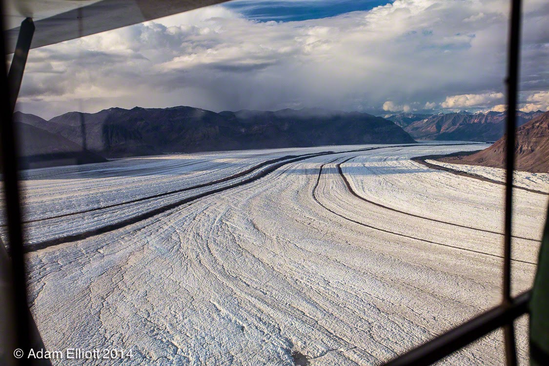
This is like the Mississippi River of glaciers. The Nabesna Glacier is over 50 miles long. When Captain Kirk (the pilot) first moved to Nabesna as a child he said it was 12 miles longer. From here we flew down to the terminus, 35 miles distant.

Another place i would have liked to have been dropped off.


This dark stripes, the lateral morraines are rubble stripped from the mountains. The rubble is thick, on the surface several dumptrucks of thickness, and they usually continue well below the surface. They stretch all the way down the glacier, 35 miles from this point. All of that rock has been removed from the mountains. It's a detailed logbook of erosion. It's all right there, neatly organized, easily measured, and it's a huge sum.


I dont' want to get too reduntant but these mountains that bordered the east side of the glacier had cool layered composition of lava flows over time. Some layers were crimson red. In the bottom left is a circular pit full of floating ice. Don't fall in there if you happen to stroll through the area.

Halfway up the glacier it breaks apart into a large lake.

I personally think what has happened here is that at this point there is a rise in the land and the glacier has lost enough thickness that it can no longer flow over the rise, so it is stuck and has melted into a large lake.

A river has emerged from the lake and is eating away the side of the glacier. You can see some seracs on the edge that are going to fall into the river.

We made it back down to where plants can grow, and it was good.

This was my favorite area since the prehistoric zone. He said it would cost $600 to be dropped of here.

I loved the terraced river banks. It looks man made but on each terrace you can see the imprint of the stream bed, and plants were beginning to grown along the patterns.

Going back a few shots you can see the plant patterns and terraces i am talking about.

Meanwhile the new river, which i am told did not exist two years ago, is doing some serious damage.

Just in front of the tire you can see the river go under an ice bridge.


This was my favorite part of the flight. This far down the moraines had melted into a series of parallel trenches. Kirk flew down into one of the trenches and followed it like we were in Star Wars.

Crazy repeating patterns in giant blocks made it seem more like a special effects sequence.

We were coming out of the trench wizzing by this stuff just over the surface.

We passed the melt pool.

The Nabesna Glacier becomes the Nabesna River.

We made our way back through scattered showers to the lodge.
The Subcontinent Wrangellia
 Reviewed by Unknown
on
16:37
Rating:
Reviewed by Unknown
on
16:37
Rating:
Reviewed by Unknown
on
16:37
Rating:


Hiç yorum yok