The Burr Trail And Other Backroads


A dry wash at the beginning of the Joint Trail.

Squeezing through some narrow stairs.

At Chester Park the rock formations are very cool but hard to walk around on because all those "cracks" are actually a network of deep slot canyons.
 It's me! Taking a break in a rare breeze that day. Photo by Jimmy Gordon


The Needles from a distance.

About to go down the Silver Stairs. This was the day after a lot of rain so there were a lot of waterpockets around and the air was slightly more humid than usual.
This visit I felt bad most of the day. I wasn't used to the heat yet, was undernourished, dehydrated and even a little motion sick from the extended rough drive. We had to get the Jeep back by 6:30pm and that fact shortened our day by more than 3 hours. Despite leaving reasonable early in the morning the going was so slow and the distance so far that when i looked at the time during our hike i was shocked that it was already 2:30 in the afternoon. We were so short on time that we never even got eat our lunch. Somehow we managed to get the Jeep back to Moab, thoroughly washed, fueled, and back to the parking lot with 4 minutes to spare before expensive penalties kicked in.

About 1/2 an hour outside Blanding we visited the Butler Wash Ruins.

There is a natural bridge next to the ruins. It's easy to accidentally walk over it because as you come over the top the hole on your right looks like it might be a water pocket. We climbed into it. The last time i was here alone so elected not to take the risk because it's an awkward climb down.

On the ceiling there are some petroglyphs.

It's kinda psychedelic in there too, like you are on the inside of some nice clay pottery.

Looking through both windows. I bet it's pretty neat with water running through it.

The ruins are on a huge slab of white sandstone called "The Comb" and the highway passes through The Comb just a short distance beyond Butler Wash.
After about a week in Colorado we returned to Utah from Durango and made a long 11 hour drive to Escalante. It could have been shorter but we did an awful lot that day. We ate at what appeared to be the only restaurant in Blanding. We stopped at Lake Powell, visited some old ruins, and drove the Burr Trail.

A distant view of Jacob's Chair (center), a 270-foot Wingate sandstone tower. was first ascended by George Hurley and Bill Forrest in November, 1976. The monolith is reached via five miles of old mining road which begins from the highway between Gravel and Long Canyons (a different Long Canyon than the other one in this post).

This was the first time i have ever seen water in White Canyon. There was a lot of flood evidence along the roads that day, and we skipped stopping in Natural Bridges National Monument due to the threat of another thunderstorm. By this time in the trip we were really tired of getting rained on.
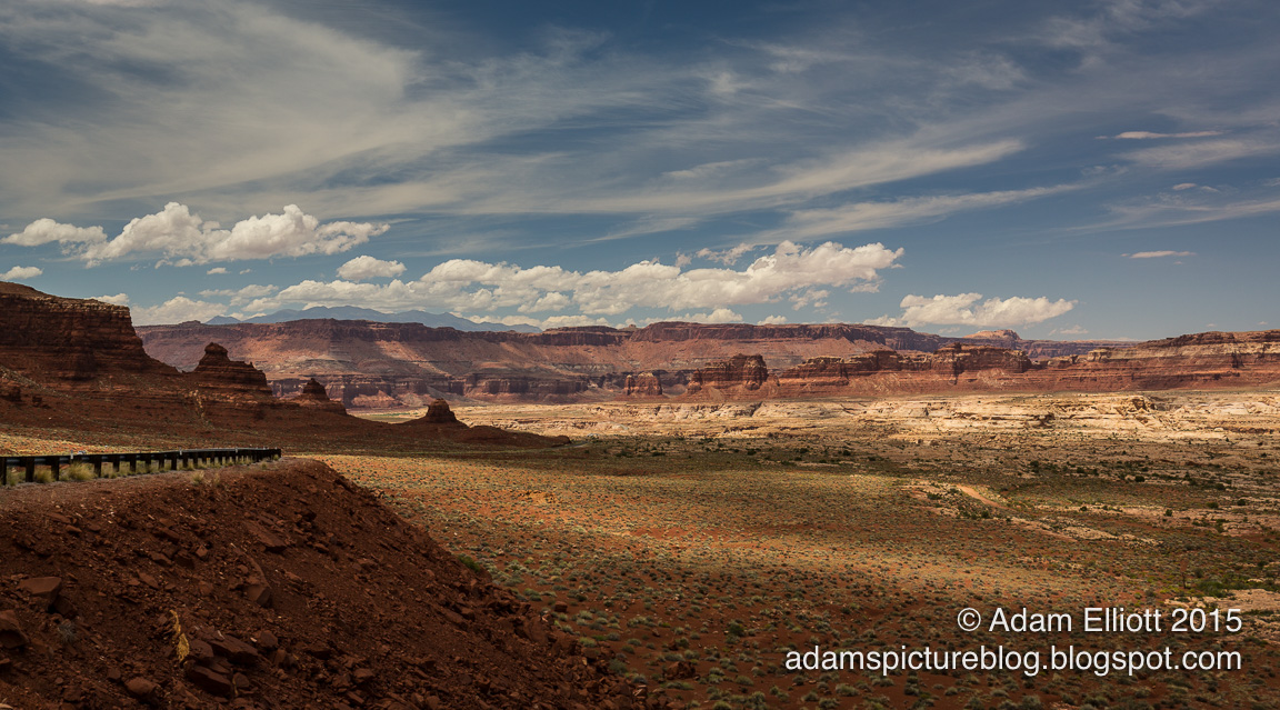

Hwy 95 between Blanding and Hanksville passes through a lot of superb, remote desert scenery.
The Burr Trail is named after John Atlantic Burr, who eventually became a cattleman/rancher in SW Utah. He developed the trail as a route to herd cattle from the lowlands around what is now the Bullfrog area of Colorado River to the highland summer ranges around the Boulder area. The original trail ran down Lower Muley Twist Canyon, which is a cool hike that nearly killed me and a friend Clint many years ago. Today the trail, which is now a half paved dirt road, bisects Muley Twist Canyon by ascending some incredible switchbacks through Capital Reef National Park.

You'd be surprised how high up you have to climb to get to these wide open flatlands with isolated chains of mesas. Unfortunately for my blog any pictures from the Burr Trail need to be viewed on a screen at least 50 inches wide.

The gray material beneath the gold hued cliffs is bentonite clay. I did not know until now that women love to rub bentonite clay all over their bodies. All i knew was that when the clay gets wet the road is totally impassable. I've been stuck in it and it was so slippery i could barely stand up.

You see it from a distance for a long time and eventually the road begins to drive right alongside the southern region of Capital Reef National Park.

Near the top of the switchbacks. In the distance are three of the great laccoliths known as the Henry Mountains (video). The last mountains put on the map in the lower 48 states, they were initially named by John Wesley Powell as "The Unknown Mountains." He later named them after Professor Joseph Henry, Secretary of the Smithsonian at time.
The Burr Trail is one of my favorite scenic areas in Utah. I spent many days and evenings exploring that trail, it's side roads, and the Henry Mountains. This trip was the greenest i had ever seen it, due to all the rain this year. The road was also considerably damaged in several places and based on the hours-old work from a team of excavators i don't know if we would have been able to drive the road the day previously. Near the very beginning just north of Bullfrog we came to a bulldozed area with large pools of water on both sides of the muddy road. There was a mud water line on the rocks next to the road that was over our heads.

Up another escarpment along the trail looking north at the Circle Cliffs.

Long Canyon is loaded with crazy rock formations

Looking south along the Circle Cliffs
All the great experiences i had in the area were the days before the internet when we had to rely on word of mouth or poorly printed black and white backcountry guide books. So this trip i was worried that the road might be crowded with other tourists since everything is so available on the internet. My worries were unfounded. In the four hours we spent traveling the route we only saw two cars and a motorcycle.

We started across pristine open desert.

I was impressed with how much life was present since the last time i had been there. Back then there was much more open sand and less cacti.

A common sight in the desert sandstone are these formations that look cut in half. I don't know how it happens. Does frost action split the rock with the fallen side buried in sand eons ago?

This tree appears to be slithering away somewhere.

We wandered through a maze of rock towers.

Jimmy investigates a narrow crack

There were enough delicate formations that i'll be keeping this hike secret. It killed me to see graffiti showing up on fantastic formations closer to the highway.
The Burr Trail offers years worth of exploring. If i were to make a photo book it might be the subject i chose to explore. We were on an epic 11 hour drive with far too much scenery to properly absorb in one day. I had to cancel a few side trips so that we had time for a short hike to a secret area I had discovered 20 years ago and not seen since. When we finally got there i was ecstatic to find no evidence of other people. No footprints anywhere. I was also awestruck at how much the vegetation in the area had grown up since i was away. My only real problem the last time i was there was avoiding big patches of cryptobiotics but this time those mats were unavoidable, and prickly pear cacti patches had filled in any gaps. Much of our time was spent looking straight down at our feet. Too look around anywhere else it was best to stop walking.

See you next time, Burr Trail, hopefully sooner than last time around.
We were very tired and hungry by the time we got to Escalante, close to 9pm. Nine pm happens to also be the time all the restaurants close in Escalante, so we had to try to get food before we checked in. When i was there 5 years before there had been a really good restaurant that was now missing from the town. We decided to go for pizza, sat down, ordered our food and drinks, and waited...... A few minutes later the waitress came back and said they were not only out of pizza but out of almost every food item on the menu! Fortunately she was nice enough to call another nearby restaurant to see if they had food and would stay open long enough for us to get there. It was well after dark by the time we found our lodging, which was a sort of motel/b&b. We had to follow some unclear directions to find our rooms, get into them, and sign up for breakfast the next morning. The next day was much more relaxing.
The Burr Trail And Other Backroads
 Reviewed by Unknown
on
20:57
Rating:
Reviewed by Unknown
on
20:57
Rating:
Reviewed by Unknown
on
20:57
Rating:


Hiç yorum yok